In the towns alongside the watercourses of Kolindsund and Grenaa, climate change have major implications – not least in relation to the areas used for agricultural production and in the meadow areas along the river basins. Taking into account the present land use, future climate changes (more precipitation, greater quantities of water in catchments, rising groundwater, rising water level in Kattegat and – possibly – salt water intrusion), as well as cost-benefit and societal analyses, a number of realistic CCA scenarios will be analysed to provide a robust and valid basis for political decision-making. This action is primarily linked to developing tools within the whole hydrological circle.
Main responsible beneficiary: Norddjurs Municipality
Number of days estimated spent on action in phase 1: 285 Days
Budget: 1.064.250€
Beneficiaries responsible for implementation: Syddjurs Municipality (SDK) and Norddjurs Municipality (NDK)
Role of Norddjurs Municipality
- Is the project-leader
- Works with stakeholders: Aqua Djurs, Syddjurs Spildevand, other wastewater companies, landowners, drainage associations, NGOs etc.
- Serves a Steering Committee (composed of Syddjurs and Norddjurs project-leaders, technical directors and politicians) and a Monitoring Group (composed of wastewater companies, Kolidsunds Venner, drainage associations, possibly politicians)
- Feeds into homepage and project portal to ensure local ownership and political consensus
-
Reports and cooperates with C2C CC PM and other C actions
Relation to Climate Change Adaption (CCA) plans
- Norddjurs CCA plan
- Syddjurs CCA plan
Activity C10 The Grenaa Cathment will gain from actions under C1 relating to desk analysis and identification of knowledge gaps and reviews of in the risk maps and planned actions.
Experience will be exchanged between demonstration projects C8, C11, C14 and C18 dealing with the coastal cities of Horsens, Randers and Juelsminde.
A common understanding between stakeholders of sustainable solutions (economically, environmentally, socially and long term) with a focus on land use, cost-effective measures, planning, implementation, maintenance and operation will be shared and developed across actions C8, C9, C11, C14, C17, C18 and facilitated by CDR. Under C1 a workshop will be held to assess synergies and possibilities of integrated solutions for the fjords at the East Coast.
Under action C2 knowledge on CCA and rivers developed under different actions will be shared. Modelling, interpretations, analysis and data sampling are similar in the different catchments and C10 will benefit from this knowledge sharing.
Scientific aspects currently the highly debated within EU, e.g. on the synergies and trade-offs between CCA and water ecology, the need for warning systems related to flooding of rivers and local contingency planning, and the synergies between farming and wetland restoration will also be shared and discussed for the benfit of action C10.
Under action C3, in selected areas a detailed local model is set up focusing on groundwater, surface and/or seawater.
Models are based on the present data and collections of new data sets e.g geophysical data and C10 will benefit from this model. Under action C3, in selected areas a detailed local model is set up focusing on groundwater, surface and/or seawater.
Models are based on the present data and collections of new data sets e.g geophysical data and C10 will benefit from this model.
Under Action C4 Rainwater, C10 will gain from the identification and experience of different setup models and testing of SUDS within CDR.
Under action C6, the groundwater-surface water model and screening tool is developed and tested, and known warning systems in DK and in other countries are explored, and simple warning systems with flood prediction are tested and demonstrated, all activities which may benefit C10 directly.
As of now, C10 is not linked to complementary actions, but the preparation of complementary projects are inherent in activities (cf. C10.3).
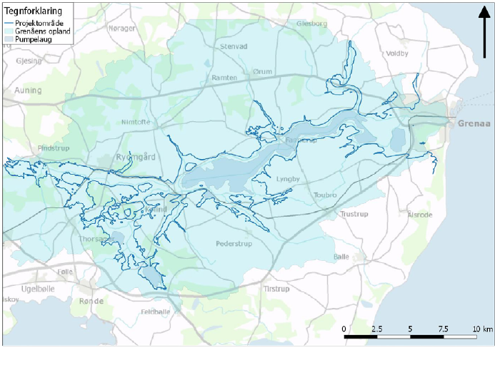
Figure19: The catchment area of River Greenaa
What
When preparing the CCA plans, analyses of the Grenaa Catchment revealed major challenges related to water management: surface water, groundwater and seawater. The project area covers 466km2. The challenge is particularly complex due to the size of the area, and different – conflicting – interests. The river estuary of the River Grenaa is the city of Grenaa, which is challenged by the future rising sea levels and water flows from the various catchments, leading to floods and problems with water supply.
In the towns alongside the watercourses of Kolindsund (the sound of Kolind) and Grenaa, climate change have major implications – not least in relation to the areas used for agricultural production and in the meadow areas along the river basins (also areas upstream of Kolindsund).
Taking into account the present land use, future climate changes (more precipitation, greater quantities of water in catchments, rising groundwater, rising water level in Kattegat and – possibly – salt water intrusion), as well as cost-benefit and societal analyses, a number of realistic CCA scenarios will be elaborated and analysed to provide a robust and valid basis for political decision-making. Where relevant, these scenarios will be extrapolated 25, 50, and 100 years to take into account future climate developments.
Among others, the following elements will be included:
- Risk assessment
- Climate-proofing of the city of Grenaa, the Kolindsund and other infrastructure in the project area (minimizing flood risk, controlled flooding, unsanitary conditions as a consequence of the overflow of the waste water systems)
- Technical requirements for climate protection in relation to agricultural production
- Implications of possible salt water intrusion for the agricultural production and the supply of drinking water
- Improved CO2 score due to CO2 retention from reintroducing wetlands
- Assessments of societal values (existing nature, outdoor recreation, settlement, and other recreational values)
Phase 1 deals with the collection of data for the hydrological model, setting up of expert/citizens forums and the creation of a website, whereas phase 2 and beyond deals with the calibration of the hydraulic model, setting up the solution scenarios, economic assessment of scenarios, qualification of the model and scenarios by organizing workshop, choose solution through economic assessments, and develop a comprehensive proposal for solutions for the project area.
What
To understand the hydrological processes in the River Grenaa catchment, to secure common knowledge and understanding of the Climate Change Adaption challenges among stakeholders, and eventually to make the proper decisions, it is necessary to set up a hydrological model.
Maximum cohesion and robustness is secured by a number of workshops with experts and stakeholders. The output of this process is a combined groundwater and salt water model to assess the Climate Change Adaption impacts on the River Grenaa catchment and its hinterland able to assess the cumulative effects and impact of the flooding, saltwater intrusion and other water balance considerations.
The model is a dynamic 3-D model (surface-ground water incl. full 3D coupled unsaturated-saturated zone) that can handle the time-related variations in the system. The following data will calibrate the model: rainfall, runoff, time-series for groundwater level, salinity, activities in drainage associations, potential evaporation, drainage, wastewater data, nitrogen / phosphorus etc. Especially in relation to groundwater, more data is needed to set up a model. Furthermore, tenders for model setup will be elaborated.
How
Phase 1:
The following sub-actions are part of the hydrological modeling:
- Collection of data and setting up a hydological model
- Workshop on needs for data to be included in the model. Participants: the C2C CC Advisory Committee, hydrologists, geologists, architects, economists, farmers' organizations, ethnographers, insurance companies, and social science experts.
- Elaboration of a tender for a model setup
Phase 2 and beyond:
Subsequent phases deal with modelling, calibration, and scenarios (2019-2020) and impact assessment of selected scenarios (2021-2022), among others:
- Model calculations for risk assessments (based on the UN climate scenarios, cumulative impacts of rises of ground water and sea level as well as increased rainfall. Sensitivity analyzes in order to qualify the risk assessments.)
- Model calculations for the screening of possible scenarios/combinations for CCA of the agricultural interests, Grenaa City, Kolind and Ryomgaard and other infrastructure. Sensitivity analysis will determine the robustness of the scenarios.
- Initial socio-economic analyzes (to decide upon the scenarios for further screening analysis).
- Impact assessment of selected scenarios, both technically and economically.
Where: The project area
When:
Phase 1: activities 1-3
Phase 2 and Phase 3: activities 4-7
What
To secure widespread awareness on the Climate Change Adaption challenges of the Grenaa catchment, and empowering stakeholders, eventually leading up to a political decision-making, a website and a portal will be created and citizens meetings held.
The website (incl. A dialogue portal) is going to be dedicated interested stakeholders and citizens to provide input and engage in dialogue on the project. The website will also regularly present analyses.
Citizens meetings will be set up, where there is a need for a more direct dialogue with citizens in the communities of Kolind, Ryomgård and Grenaa.
How
Phase 1:
- Launching of a website incl. Life logo and linked to C2C CC website
- 1 – 2 Citizens meetings to disseminate results. Depending on how many sign up to the citizens’ meetings, one will be in the east and one in the west of the project area to secure that all citizens are heard.
Where: Norddjurs and Syddjurs municipalities; the website, which is a local instrument to serve the action, will be linked to the C2C CC website.
When: This activity is an important element of the project and will take place all years and beyond.
What
Finding solutions to the Grenaa catchment Climate Change Adaption challenges not only require thorough analysis and awareness raising, but eventually also a political dialogue – among local stakeholders and across municipal boundaries.
A dialogue within the Steering Committee and the Monitoring Group will deal with trade-offs. This dialogue is to create ownership, and continuing discussion and decision on the project and its scenarios. This ensures dialogue with politicians, stakeholders and interest groups represented in either group.
And to secure even better basis for decisions, workshops with the participation of representatives from the Advisory Committee will be organised, and findings from C2C CC analyses on the legal and administrative fields will be included. As a result, scenarios to be further investigated in Phase 3 will be chosen.
Phase 1:
- Public meetings and a conference with representatives from the Norddjurs and the Syddjurs City Councils, discussing scenarios with citizens and other stakeholders to secure political attention and cooperation between the two neighboring municipalities on this issue
- If need be, local project groups wanting to work deeper on aspects of the project will be established.
Phase 2 and beyond:
In phases 2 and 3, the prioritization tools are supposed to include aspects such as outdoor recreation, recreational, health, tourism, etc apart from the technical assessments, as well as cost-benefit analyzes of the chosen solution. Additional complementary projects will be established.
Where: Norddjurs and Syddjurs Municipalities
When: Phase 1-3 and beyond
Climate changes put extreme pressure on cities and agricultural areas within the whole project area. CCA must be carried out to the benefit of citizens, society and the area itself.
However, within the area, many interests and issues are in conflict, but may eventually complement and match one another.
To reach that situation, the landowners, drainage associations, interested companies including wastewater companies and organizations must be engaged, and a thorough modelling and review analysis including analyses of various parameters, the handling of accumulated effects are necessary to involve stakeholders and to include them in defining the possibility of a solution.
The models and tools form the basis for a common understanding among the two municipalities and its stakeholders when having to decide on CCA solutions and its impact on e.g. biodiversity, environment CO2, socio-economic benefit and legal questions.
In addition, the project, in combination with the other C2C CC sub-projects, will provide knowledge and generate manuals and initiate innovative elements for handling CCA that can create value locally, regionally, nationally and in general in the EU.
The large project area contains many divergent interests to be weighed and lifted to a common strategy for the area's CCA.
Over the past years, the Grenaa catchment has been subject to much debate and strong interest in maintaining the existing land use for agriculture, or if old landscapes with wetlands should be restored. These conflicting interests have often been publicly debated, and political debate and strong attitudes and ideologies have been put to the open. The project intends to clarify and provide answers to questions and solutions to the issues that have flourished for many years. Being holistic, the project will help to balance the various interests. A common platform of knowledge to communicate from a common strategy for the region in the long term shall help in this endeavor. Municipalities prioritize that the project is transparent and call for a great deal of dialogue, based on mutual respect. The Steering Committee and the Monitoring Group shall, as well as an ongoing dialogue in the project phase, shall ensure this.
C10.1: Phase 1: Knowledge and a common understanding of the CCA challenges linked to the Grenaa Catchment and the Kolindsund. Total number of hectares screened: 470.
C10.2: Public awareness and public discussion on CCA and the challenges linked to the Grenaa Catchment and the Kolindsund. Number of citizens reached: around 500.
C10.3: Phase 2: Awareness and knowledge is build at political level and dialogue between politicians of the two municipalities is established, and decisions of 1 or more integrated solutions, incl. costs and proposed financing are presented to politicians of both municipalities to be decided on.
Expenses for direct personal costs are based on person days for NDK and SDK personel based on present salaries and pensions, etc. Expenses for external expert help is based on prior experience with external assistance to local projects in the municipalities. External assistance will be used for highly needed expertise in relation to the modeling. During Phase 2 will cover the further development of the model, calibration and calculating various scenarios under various conditions and including socio-economic assessments, incl. environment and nature. During Phase 3 expenses will cover final works on models, comparisons, tools, guidelines, a meeting with citizens.
C10.1
- Calibrated hydraulic model for the Grenaa Catchment
- Idea catalogue with possible solutions and assessments for CCA in the project area
- Catalogue with selected solutions and their in depth analysis
C10.2
- Website incl. a dialogue portal
C10.3
- Strategic plan for the area and its climate adaptation
C10.1
Phase 1:
31/12/2018: Workshop held on qualifying data sampling
31/12/2018: Collection of data for the model and other assessments done
31/12/2018: Tendering material developed for model and impact assessment
Phase 2 and beyond:
31/12/2022: Elaboration of model and calibrating done
31/12/2022: Screening and qualifying options incl. risk assessment done
31/12/2022: Assessment onAon environment, nature and recreational values done
31/12/2022: Impact assessment of chosen scenarios and prioritization (2021-2022)
31/12/2022: Solutions for political decision-making identified
C10.2
31/12/2018: Launching of Website incl. a dialogue portal
31/12/2022: Citizens meetings held, 500 participants
C10.3
31/12/2022: Public meetings and a conference with representatives from the Norddjurs and the Syddjurs City Councils, 100 participants