This action deals with sustainable Climatge Change Adaption through a holistic sustainable concept with a specific focus on increased infiltration in urban areas, in particular new urban development areas.
Due to the lack of basic knowledge, it is difficult for the municipalities to give firm advise to the developers on where and how to manage surface water by infiltration.
For the purpose of mapping the infiltration potential in urban development areas, areas will be mapped with high-precision geophysics, which may show in detail the upper 5 to10 meters of the ground surface.
Relevant stakeholders will be involved in in an integrated stakeholder process, where technical results will be transformed and disseminated through field trips, workshops and subsequent development of description of best practices and guidance for stakeholders on how to best make use on infiltration of surface water in future urban development projects.
In the end the stakeholders will define coming complementary projects. This action is primarily linked to innovation within groundwater and rainwater.
Main responsible beneficiary: Horsens Municipality
Number of days estimated spent on action in phase 1: 242 Days
Budget: 175.388€
Beneficiary responsible for implementation:
Horsens Municipality (Horsens) and VIA University College (VIA) are project managers.
Role of Horsens:
- is responsible for progress in C23, providing advice and contact with the stakeholders.
Role of VIA:
- is responsible for executing the infiltration measurements, drillings, geophysical mapping and the production of a detailed infiltration potential map for urban areas.
Relation to Climate Change Adaption (CCA) plans
The action is a consequence of Horsens CCA plan, aiming at preventing consequences of climate change by using increased infiltration in future urban areas with specific reference to page 7 in the municipality´s CCA plan.
What:
The Horsens city and its suburbs is the project area for this action, covering the possibilities of infiltration of surface water in urban development areas throughout the municipality’s urban development areas.
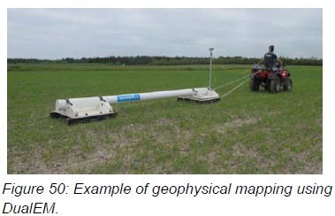
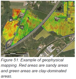
For the purpose of mapping the infiltration potential in urban development areas, areas will be mapped with high-precision geophysics, which may show in detail the upper 5 to10 meters of the ground surface, see Figure 50 and Figure 51. In connection with the geophysical mapping, supplementary manual drillings up to 1 to 5 meters depth will be carried out, describing lithology and grain size analyses in detail.
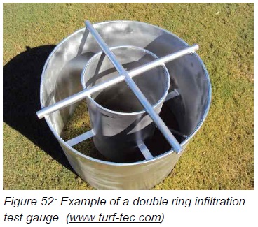
As an extension of the geophysical mapping, infiltration tests cf. Figure 52 are made with different clay types found in urban development areas. The aim is to carry out field studies to a sufficient degree, making it possible to perform a quantitative (statistical) clarification of the individual soils’s infiltration capabilities. The results of the executed infiltration tests form the basis for examining to what extent there exists a quantitative correlation between the geological descriptions and the soils’ infiltration capabilities.
Similarly, the resistivity measurements from the geophysical mapping will be compared with the results from the infiltration tests, to ascertain whether a quantitative correlation exists between the deposits’ electric resistivity and the infiltration capabilities. Based on the soil types’ different infiltration capabilities, it will be possible to produce a detailed infiltration potential map for urban development areas.
How:
Action C23.1 includes:
- Quantitative (statistical) clarification of the individual soil’s infiltration capabilities. By finding a quantitative correlation between the individual soil type and their infiltration capabilities, results can be immediately transferred to similar areas, for example, with the use of a soil type map.
- Quantitative correlation between the geological descriptions from the drillings and the soils’
infiltration capabilities. By finding a quantitative correlation between the geological descriptions from drillings and the soils’ infiltration capabilities, stakeholders and municipalities have the opportunity in the future to be able to express whether the area’s infiltration capabilities are valid based on new and existing descriptions from drillings. - Quantitative correlation between the soils’ electrical resistivity and infiltration capabilities. By finding a quantitative correlation between the soils’ electrical resistance and their infiltration capabilities, stakeholders and municipalities are in the future able to carry out geophysical mapping and thus gain an overview of the area’s infiltration potential.
- Production of a detailed infiltration potential map for urban development areas. In connection with the preparation of a infiltration potential map, a number of guidelines will be written, which describe how the map is made and which data are necessary.
- The creation of a professional knowledge base for the municipalities’ formulation of best practices and guidelines for local management of precipitation in urban development areas. Reports on best practices and guidelines that describe how data shall be used and interpreted. The results will be reported to other municipalities and stakeholders with similar challenges on an ongoing basis, so that experience from the project can be passed on and widely dispersed.
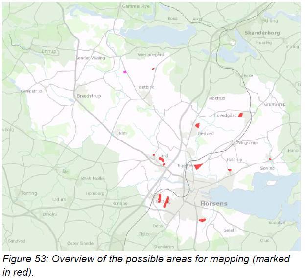
Where: Horsens city and suburbs is project area. However, the methodology developed is relevant for all C2C CC partners. The project area covers approx. half of a total of 490 ha, where Horsens has designated development areas for new homes. See Figure 53.
When: January 2017 – December 2018
Phase 1:
It is planned that action C23.1 will be executed over the first two years (2017-2018)
C23.1 will have expenses for external expert consultation in connection with geophysical mapping. It is expected that approx. 18 ha/day can be mapped, which gives a total of 14 days in the field. In addition, it is expected that 320 infiltration tests will be carried out.
Expenses for external expert consultation are expected to be DKK 400,000, based on inquiries.
In connection with C23.1 it is expected that Horsens Municipality and VIA University College will contribute by providing advice, execution of drillings, data processing and the interpretation of data. Horsens Municipality will contribute with 100 hours and VIA 1704 hours. In connection with project C23.2. it is expected that Horsens Municipality and VIA University College will contribute by providing information, reporting and meeting activity in collaboration with stakeholders.
In connection with project C23.3, it is expected that Horsens Municipality and VIA University College will contribute by providing information, reporting, planning of workshops and the final conference. For Hedensted Municipality the total number of person-days per year is based on the basis of the total working hours/days according to national legislation, collective agreements, employment contracts, etc. – budgeted at 214 days per year.
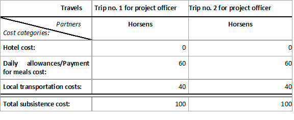
Subsistence costs are based on prior experience and can be further subdivided into Hotel costs, Daily allowances/Payment for meals and local transportation categories, as shown below for this action’s subsistence costs items: