The town of Horsens is threatened by floods, because a major part of the town centre is lower than 1.5 meter above the normal sea level in the Horsens Fjord. With rising sea levels and amounts of water from watercourses in the hinterland due to increasing precipitation and more powerful downpours, there is an urgent need for securing the lowest lying parts of the town against flooding.
This action analyses and lays out scenarios containing all relevant issues regarding flooding from the fjord, the watercourses and handling of the sewer systems. It also deals with the development of the port area, which is being converted into a residential, recreational and commercial area.
This action is primarily linked to governance and tools within most areas of the hydrological cycle apart from groundwater.
Main responsible beneficiary: Horsens Municipality
Number of days estimated spent on action in phase 1: 220 Days
Budget: 709.302€
Beneficiary responsible for implementation: Horsens Municipality is the overall project manager.
Role of Horsens Municipality:
- Is project manager
- Has the contact to C2C CC project management
- Coordinates with HEDKOM on exchange of data about diverted water amounts from walled areas and on the possibilities for retaining water in the catchment area as well as with Vejle Municipality on similar information.
Relation to CCA plans
In the municipality’s CCA plan, Horsens town centre is designated as focus area 12, cf. Figure 1 (page 34 in the CCA plan). The figure shows that the focus area is the most critical, assessed on the basis of the parameters risk of flooding and highest value, and it is therefore very important to make it flood-proof.
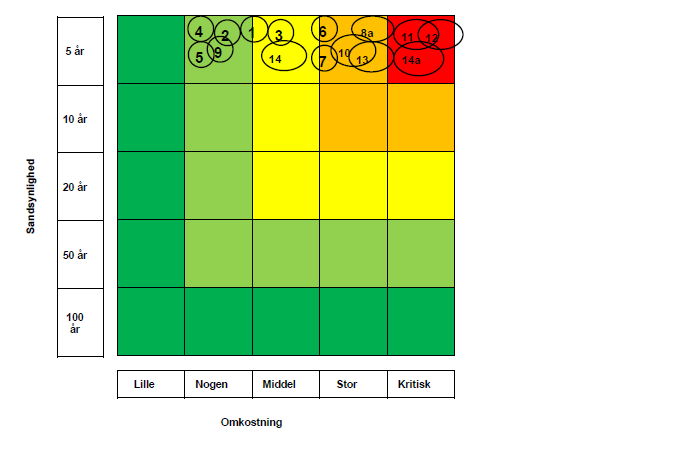
Figure 23: In Horsens Municipality’s climate change adaptation plan,
Horsens Town Centre is focus area 12, the most critical.
Action C14 Flood-proofing Horsens Town Centre will gain from actions under C1 relating to desk analysis and identification of knowledge gaps and reviews of in the risk maps and planned actions.
Experience will be exchanged between demonstration projects C8, C10, C11 and C18 dealing with the coastal cities of Randers, Grenaa and Juelsminde.
A common understanding between stakeholders of sustainable solutions (economically, environmentally, socially and long term) with a focus on land use, cost-effective measures, planning, implementation, maintenance and operation will be shared and developed across actions C8, C9, C11, C10, C17, C18 and facilitated by CDR.
Under C1 a workshop will be held to assess synergies and possibilities of integrated solutions for the fjords at the East Coast.
Under action C2 knowledge on CCA and rivers developed under different actions will be shared.
Modelling, interpretations, analysis and data sampling are similar in the different catchments and C14 may benefit from this knowledge sharing in relation to the Bygholm cathment area (figure 25).
Scientific aspects currently the highly debated within EU, e.g. on the synergies and trade-offs between CCA and water ecology, the need for warning systems related to flooding of rivers and local contingency planning, and the synergies between farming and wetland restoration will also be shared and discussed for the benefit of action C14.
Under Action C4 Rainwater, C14 will gain from the identification and experience of different setup models and testing of SUDS within CDR.
Under action C5 specific training courses, workshops and masterclasses, with point of departure in the challenges experienced by the partners will be implemented for the benefit of action C14 and other actions.
Linked to Complementary Actions
C14 will coordinate with Horsens wastewater utility on the integration of an urban hydrological model of the sewer system of Horsens town, which will be completed during 2017.
What:
Horsens town is threatened by floods, because a major part of the town centre is lower than 1.5 meter above the normal sea level in Horsens Fjord. With rising sea levels and now with more water from watercourses in the hinterland due to increasing precipitation and more powerful downpours, there is a great need for securing the lowest lying parts of the town against flooding, cf. Figure 24 and 25.
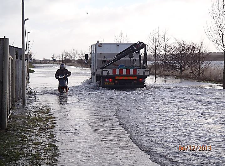
Figure 24: Picture of flooding at the outlet of Bygholm Å and in Bygholm Park in December 2013
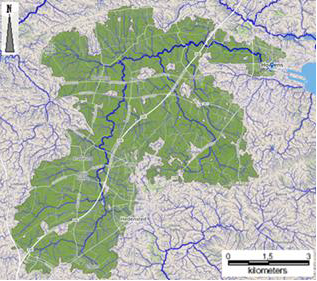
Figure 25: Map of Bygholm catchment area
The aim of C14 is to secure Horsens town centre against flooding when there is a storm surge and/or extreme flows in the three watercourses Dagnæs bæk, Bygholm and Hansted Å, which all run through the town. It requires overall considerations and scenarios of flooding for the fjord, watercourses and sewer systems, and holistic planning and coordination in relation to the port area Nordhaven, which is being converted into a residential, recreation and commercial area. An initial project was carried out by Horsens Municipality (ends April 2016) forms the basis of C14 with the purpose to carry out a detailed project design for flood proofing of Horsens town. The initial project, hereafter the 2016 project, included a simple watercourse model and involves an outline of proposed solutions to prevent flooding from precipitation, watercourses and sea levels under saturated and stationary conditions, respectively. The possible solutions are outlined for short-term flood proofing at a level off 1.8 meter above normal sea level, and a politically adopted long-term flood proofing at a level of 2.6 meter above normal sea level, se example in Figure 24. The results of the ‘2016 project’ proposes water retention in the catchment area and dike solutions using sluices and pumps in Horsens town. However, political reality are likely to change, and there has been discussions on establishing a small-scale barrier solution on the sea floor in Horsens’ outer fjord, inspired by the Mose Project in Venice. The ‘2016 project’ sets the basis of C14.
Action C15 supplements action C14 by its nuanced approach to the drainage of water, so that the production potential of farming is developed, and the towns do not end up functioning as delay reservoirs, when the watercourse has high flows. We expect that the two actions can greatly benefit from each other. The aim of C14 is furthermore to provide inspiration to the development of other solutions in other coastal towns that are threatened by rising sea levels and/or water from the hinterland catchment area.
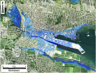
Figure 26: Consequence map for flooding with preliminary outlined proposal that will protect Horsens town in the short term?, equivalent to flood-proofing at a level of 1,8 meter DVR90. The floof proofing will be established using a high tid wall earth dykes and mobile water tubes.
How:
C14 will be contain the following activities: preparation of tender material and tender phase for external expert assistance for step 2 to 5; provision of knowledge in the form of status, data collection and model set-up; scenario calculations and initial stakeholder involvement; preparation of proposals and stakeholder involvement; preparation of project design and invitation to tender material for contractors; flooding related to watercourse Store Hansted Å and the northern part of Horsens town.
Where:
The project area covers Bygholm Å catchment area and extends to HEDKOM and Vejle Municipality, cf. Figure 27. Bygholm Å catchment area drains into the watercourses that flow through Horsens town centre and out to Horsens Fjord. The main focus is on Horsens town centre and covers the port, parts of the inner town and Bygholm Park, which will be flooded with a 5-year storm surge event in 2050 (2.4 m DVR90), cf. Figure 28.
Figure 27 All of the Bygholm Å catchment area with flow paths on terrain.
Figure 28 Flooding in Horsens town with a 5-year storm surge event in 2050, equivalent to 2.4 m above normal sea level (Horsens CCA plan p. 34).
When:
Phase 1: Activity 14.1-14.3
Phase 2 and beyond: Activity 14.4-14.5
This activity is based upon the above mentioned pilot project and the purpose is to find the most suitable and cost efficient external expert to aid in the following four activities.
Preparation of tender material.
The following sub-activities are involved:
- A workshop for Horsens Municipality’s steering group for Climate Change Adaption, where the status of the pilot project is processed and potential solutions and recommendations to be worked further in C2C CC is decided.
- The pilot project is based on a simple hydrological model, and it is expected that there is a need for setting up a dynamic model, which can calculate the total flooding for watercourses, the sewer system and seawater. The model will be calibrated at a detailed level and can be used as the basis for the creation of an overall plan for avoiding flooding in Horsens town centre. It may be necessary to conduct further data collection in the form of e.g. water flow measurements, water levels, measurement of the terrain and watercourse, etc.
- Establishment of an online portal with connection to the portal of C2C CC. The portal will be maintained on an ongoing basis in accordance with the agreement with the C2C CC project management.
- Preparation of a communication plan of C14 involving when and how stakeholders and citizens can be involved and heard in the action on an ongoing basis. Communication may take place for example, via digital media, written material, stakeholder and citizen meetings, e.g. meetings with NGOs in the municipality, etc.
- Scenarios will be calculated for the contemporary and future climate, which will be used to provide the basis for planning and making decisions for the management of floods. Scenarios will be calculated with the clarification of consequences of:
- Storing water in the catchment area.
- Using the lake Bygholm Sø as a reservoir. It is today possible to lower the water level 0.5–1.0 m and thus achieve a significant reservoir capacity.
- Establishing permanent and mobile dike solutions in the town.
- Establishing permanent sluices and pumps in the inner port, alternatively in the outer port.
- The scenarios will be carried out as a combination of the above for the purpose of optimising the most beneficial solution.
- Selecting optimal areas for storing water and assess retention potential in the catchment. Storing of water contributes to achieving goals in the EU’s WFD. The natural hydrology shall be recreated in the catchment area through periodic flooding of low-lying areas along the watercourses. This will reduce the risk of flooding in Horsens town and reduce discharge of nitrogen and sulphur into Bygholm Sø and Horsens Fjord, and benefit achievement of the WFD goals of obtaining a good environmental state (Synergies with C12 and C15).
Dialogue with stakeholders:
- Coordination and knowledge exchange with Action C12 and C15.
- Dialogue between HEDKOM and Vejle Municipality about the possible retention of water in their part of the catchment area. This activity may also involve an
- Preliminary dialogue and survey of locations with the affected landowners, e.g. farmers, for the purpose of establishing a broad ownership of the results.
- Preliminary dialogue with the affected businesses and citizens in the town centre.
- If required, inspirational trips for a committee of representatives from the municipalities. A trip could be for example, a visit to England for the purpose of finding inspiration in learning how the English EU LIFE project River Trusts work with the overall water management within major catchment areas.
- Outlining of solutions: based on model scenarios and the effect of different means (permanent high tide walls, earth dikes, mobile water tubes and dikes, sluices and pumps), and visualisation of reduced flooding in the form of a consequence map.
- Preparation of proposals:
- Decision on the most suitable solution for Horsens town
- Architectual visualisation of solutions and possible film sequences illustrating the level of flooding before and after protection.
- Budgeting of construction costs and calculation of other cost-benefits considerations in relation to prioritised protection of assets.
- Stakeholder involvement: Visiting other coastal cities in Denmark with politicians, with similar climate adaption challenges.
- Coordination with the municipality’s emergency services and contingency planning team on the use of mobile protection measures.
- Workshops with HEDKOM and Vejle Municipality on retention possibilities in Vejle Municipality and HEDKOM.
- Continued dialogue with stakeholders.
- Workshop/seminar with the C2C CC partners with presentation of the results of C14.
- Stakeholder agreements:
- 11. Agreements with Horsens waste water utility on the financing obligations.
- 12. Agreements with Vejle and HEDKOM on responsibility and financing between the affected municipalities.
- 13. Potential action on development of a system for smart management of sluices and pumps (inspiration from on-going industrial PhD project).
- Preparation of a conceptual design and invitation to tender material for contractors for the selected solutions.
- In year 2021-22 C14 will focus on flooding issues in other parts of the municipality (Horsens CCA plan pp. 25-35) with special attention to floodings related to the watercourse Store Hansted Å, including the northern part of Horsens town, where houses close to the watercourse periodically are flooded.
Horsens town centre covers central town functions, including homes, companies, technical installations and a town park. The area consist of major economic assets that are at risk (Horsens CCA plan p. 21, cf. risk map). The project benefits the overall aim of C2C CC in creating a climate resilient town by implementing the local CCA plan’s most prioritised challenge and in collaboration with the affected parties.
C14 will coordinate with Horsens wastewater utility on the integration of an urban hydrological model of the sewer system of Horsens town, which will be completed during 2017.
C14 may be delayed according to the schedule of this model, since it shall be included as an integrated part of C14 model. In relation to the integrated model carried out in C14, it may be necessary to conduct further data collection (see activity 2), which could affect the schedule.
Initial correspondence with the municipalities of Vejle and HEDKOM on C14 has taken place, however, resistance to upstream solutions may occur if win-win solutions are not defined. This issue is counteracted by including technicians and politicians from the two municipalities in the project.
Uncertainty related to financing implementation of solutions: internally in Horsens Municipality, between Horsens Municipality and Horsens Waste Water utility, and between the municipalities of Horsens, Vejle and HEDKOM. Early involvement of the established steering group for CCA and politicians will aim to find a fair solution for financing.
Expected results for Phase 2:
The action will result in basis for decision making on which outlined solution possibilities will be worked further and clarify which additional matters that need to be clarified, whereas it is possible to define long-term solutions for protecting Horsens town centre from flooding that meet the politically adopted level of protection for the municipality (stated in the CCA plan).
The following will be defined: Designated local sites and solutions for retaining water in the catchment area in one or several locations - if needed. Designated most suitable positioning of dike reinforcements that protect Horsens town centre. Calculated filling times for any reservoirs, and calculated dimensioning of pumps and sluices with different scenarios in the current and future climate. A smart pump and sluice control system. Solutions for water flow and for the catchment area that promote biodiversity as much as possible, improve water quality and provide recreational options for local residents. With Nordhavnen under redevelopment, solutions shall be provided for traffic connections to the port area and the central neighbourhood. Dikes, sluices and pumps are designed to be visually inspiring and to provide recreational urban spaces, and integrated into the urban life of Horsens town.
Expected results for Phase 3:
Mapped and estimated flooding risks related to the watercourse Store Hansted Å, and the interaction with Horsens Fjord and the lakes like Nørrestrand. Prepare a decision base to determine wheter climate mitigation are needed and if necessary, decide wich climate adaption action are to be carried out.
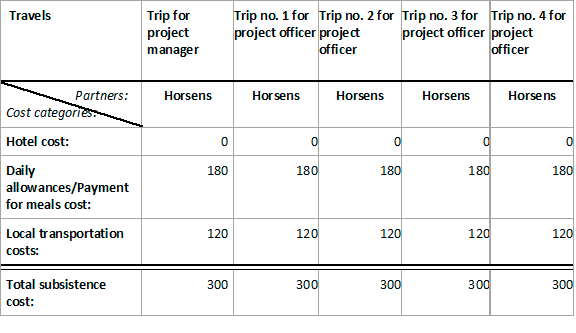
Expenses for direct personal costs are based on person days for Horsens personel based on present salaries and pensions, etc. Expenses for external expert help is based on prior experience. External assistance will be used for highly needed expertise in relation to scenario calcultaions.
Subsistence costs are based on prior experience and can be further subdivided into Hotel costs, Daily allowances/Payment for meals and local transportation categories, as shown below for this action’s subsistence costs items:
C14.1
Phase 1:
- Status report for pilot project
- Report on model formfor scenarios for the total flooding
C14.2
- A status report of the ‘2016 project’.
- Minute stating steering group decision on outlined solution.
- Report with requirements and expectations for the C14 model.
- Online portal connected with C2C CC online platform incl. LIFE Logo.
- Communication plan for stakeholder involvement.
- Scenarios and sensitivity analysiswill be calculated for the contemporary climate with a Status 2018 model, which will be used to provice the basis todays challenges, and for planning and making decisions for the management of floods.
- Mapping of nature values, and prioritize locations for retaining water in Bygholm Å catchment area.
- Using the lake Bygholm Sø as a reservoir. It is possible to lower the water level 0.5m and thus achieve a significant reservoir capacity
- The probability of simultaneous contingency between precipitation events, high flow watercourses and storms is estimated.
C14.3 - 14.5
Phase 2:
- Planning scenarios with tecnical background report of model methodology and results is delivered.
- Background report with designated local sites and needed solutions.
- Tecnical report on calculated filling times for reservoirs and dimensioning of pumps and sluices.
- Background report on solutions for water flow and for the catchment area, that if possible improve water quality and provides recreational options for local residents.
- Proposals for best climate adaption solutions:
- Masterplan for long term climate adaption according to cloud bursts, stream flow and flooding from the fjord.
- A construction program for technical facilities.
- Presentation and visualization - The above is part of topics in tender prime 2019 - where use of new infrastructure, recreational urban spaces.
Sluice, pump solutions is expected to be in focus.
Phase 3 :
C14.6
- A decision base to determine whether climate adaption are needed and if necessary, decide what action should be taken.
C14.1 and C14.2
Phase 1:
31/12/2017 : Collection of data finalised
30/06/2018 : A model is set-up to calculate scenarios for the total flooding from the sea, watercourses and sewage systems.
31/10/2018 : Consultant for the execution of phase 2 14.3 and 14.4 is selected.
31/03/2019 : Possible locations identified for retaining water in the Bygholm Å catchment area.
C14.3
Phase 2:
31/12/2019 : Possible solutions identified for retaining water in the catchment area, including both in the open countryside and from the urban areas.
30/06/2020 : Specific solutionsss proposed for water retention, dikes, pumps and if required, barriers in the fjord.
C14.4
31/12/2019 : If needed CBA analysis finalized in relation to the assets that shall be protected.
31/12/2019 : Involvement of citizensc and politiciansin the development of the solutions done, public involvement is carried out according to assessed needs.
31/12/2019 : Construction programme, and cost estimations for construction solutions finalized, part of tender in prime 2019
30/06/2020 : Final political approval of the described solutions done.
C14.5
31/12/2020 : Preparation of a conceptual design and disposal project for the needed solutions.
C14.6
Phase 3:
2021-2022 :
CC14 will focus on flooding issues in other parts of the municipality (Horsens CCA plan pp.25-35) with special attention to floodings related to the watercourse Store Hansted Å, including the northern part of Horsens town, where houses close to the watercourse periodically are flooded.