Randers City Council has a vision to connect the city to the water by 2021.
Historically an industrial city with a busy port, the city now faces its back to the water and the nature. However, soon the industrial area will be abolished, and a possibility for the city to turn to the water has emerged.
New Climate Change Adaption (CCA) measures will be developed and implemented while fully respecting the unique nature of the Randers Fjord and the River Gudenå, bringing biodiversity closer to the city and generating nature based recreational activities close to the city center.
The project defines the contents of the Climate Ribbon and the subsequent launch of an international tender for innovative nature-based solutions.
The project involves investors, citizens, politicians and other stakeholders.
This action is primarily linked to governance within all aspects of the hydrological cycle apart from groundwater.
Main responsible beneficiary: Randers Municipality
Number of days estimated spent on action in phase 1: 1206 Days Budget: 678.111€
Beneficiary responsible for implementation: Randers Municipality (RK)
Role of Randers Municipality
- Is the project leader
- Works with the following secondary stakeholders: Randers Spildevand (Randers Wastewater), Randers Havn (Randers Port), landowners within the Climate Ribbon as well as with citizens, investors and others
- Reports and cooperates with C2C CC PM, and other C2C CC demo projects
Relation to Climate Change Adaption plans
- Randers Municipality CCA Plan
- Randers risk management plan
The Climate Ribbon is an area between the city and the River Gudenå/the Randers Fjord, and is a significant part of the city's overall urban development project “The City to the Water”. The area is appointed as a risk area R1 in the municipal CCA Plan. The CCA plan refers to the Flood Risk Management Plan regarding implementation of initiatives, and within the latter, the project "City of Water" is a major part of the plan containing several purposes and actions.
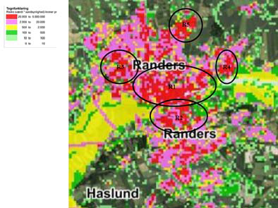
Figure 37. With 62,000 inhabitants (the 6th largest city in DK), Randers is situated at the river mouth of the northern part of the River Gudenå at the estuary of Randers Fjord, between the hillsides of the vally of the River Gudenå to the north and south.
Randers City Council has a vision to connect the city to the water by 2021
Historically an industrial city with a busy port, the city now faces its back to the water and the nature. However, soon all port functions shall be totally relocated to another area along the fjord, the industrial area will be abolished, and a possibility for the city to turn to the water has emerged.
Thus, convening the city, the nature, and the water constitutes a major potential for future urban development. New CCA measures should be developed and implemented while at the same time fully respecting the unique nature of the Randers Fjord and the River Gudenå, bringing biodiversity closer to the city and generate nature based recreational activities close to the city center.
‘The City to the Water’ covers 92 hectares along the River Gudenå and the Randers fjord. The previous industrial and port area must be climate-proofed for urban development without losing its direct, attractive location at the center of nature with easy access to the water. In this process, Randers Municipality is seeking means to find new, innovative CCA solutions and mobilise investments (the C16 action) protecting the city agaings flooding by storm surge, while keeping direct and close contact with unique nature and future acces to water.
Traditional CCA based on embankments, dams and dikes saves the city from water damage, but also creates new barriers between the city and the water, resulting in a poorer experience of nature and greater distance between the city and the water. New buildings on high plinths create closed facades and dreary spaces that are not pleasant to pass by.
Climate Ribbon
An important feature of the urban development project is the creation of a new large coherent ‘Climate Ribbon’ connecting the city with the countryside to the east and west and at the same time connecting it to the water. The Climate Ribbon is a green corridor of 8.8 km, winding between the city and the water. Here, docks and embankments, urban nature, infrastructure, buildings, urban spaces, and city life integrate into one large CCA project.
Furthermore, the relocating of the port operations, and reducing of the traffic on Randers Bridge, two types of water could easily merge with a positive impact on biodiversity in this area. The meeting between the salty water of the Randers Fjord and the fresh water of the River Gudenå an improved water environment create the basis for a healthy and stable ecosystem with the potential of more animals and plants as well as new species of fish, birds and insects.
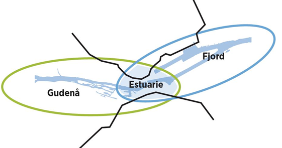
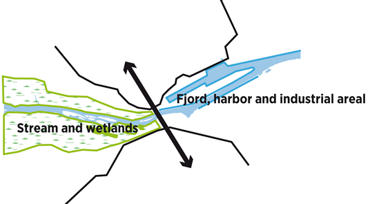
Figure 38: the merger of the two types of water – the fresh water of the River Gudenå and the salty water of Randers Fjord
The ultimate goal is to avoid new barriers between the city and the water, and instead include water as a positive resource and an active part of the solution to the city's challenges. However, solutions are not evident, so the purpose of the project is to gather knowledge and innovative CCA answers, disseminate and consolidate this knowledge, and create new experiences and eventually generate investments and continued momentum in the realization of the project.
Phase 1 deals with collecting relevant data on the contents of the Climate Ribbon and the subsequent launch of an international tender for innovative nature-based solutions.
Working on the Climate Ribbon – and linking it to city development – is a huge task, and a lot of personnel cost is allocated to it.
Furthermore, expenses for external expert help is expected to amount to 241,452 € based on prior experience with external assistance to local projects and best judgements. Estimation of person days for RK is based on present salaries + pension etc.
A professional international landscape/arhictectual tender (C16.2) will cost an estimated €187.796. We expect to attract the best innovative teams from all over Europe.
We will need a sum of €134.128, for buying the rights of the three best proposals in the tender.
Additonal we will need funds to prepare the material for a round of prequalification to select 6-10 competitive participants, from where we will find the winners.
The residual sum of €53.668 will cover external prossional help for writing up the programme description and tender rules, transalation of the material for the selection committee, meetings and public presentations of the tender proposals.
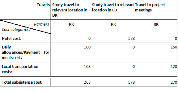
Subsistence costs are also based on prior experience and can be further subdivided into Hotel costs, Daily allowances/Payment for meals and local transportation categories, as shown below for this action’s subsistence costs items: